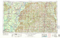
1953 Map of Natchez
USGS Topo · Published 1975About this map
The Mississippi River creates a meandering border between Louisiana and Mississippi in this mid-century survey, defining a landscape of oxbow lakes and alluvial plains. Large water bodies like Lake Bruin, Lake St. John, and Lake Concordia trace the former paths of the river, while the Tensas River and Ouachita River drain the lowlands to the west. On the eastern bluffs, Natchez stands as a primary hub, connected to the interior by the Illinois Central Railroad and a network of highways including US Highway 61 and US Highway 84.
Find a feature on this map
87 named features on this map. Tap any name to fly to it.
Don’t see what you’re looking for? This feature index may not catch every label — zoom into the map to look around manually.
Map Details
Editions of this 1953 Natchez Map

Other maps of this area

1903 · Jackson
USGS Topo · 1:125,000

1906 · Bayou Sara
USGS Topo · 1:125,000

1906 · Florence
USGS Topo · 1:62,500

1908 · Florence
USGS Topo · 1:62,500

1909 · Delta Bridge
USGS Topo · 1:24,000

1909 · Sycamore Landing
USGS Topo · 1:24,000

1909 · Lake Bruen
USGS Topo · 1:24,000

1909 · Vidalia
USGS Topo · 1:24,000

1921 · Natchez
USGS Topo · 1:48,000

1922 · Natchez
USGS Topo · 1:62,500