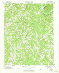
1968 Map of Nathalie
USGS Topo · Published 1971About this map
The Norfolk and Western railroad forms the spine of this rural landscape, connecting small agricultural communities and family-named hamlets across northern Halifax County. The settlement of Nathalie serves as a central hub, while the railroad passes through Lennig and Clarkton as it follows the drainage patterns toward the Roanoke River along the northeastern boundary. This river segment marks the border with Charlotte County, winding through a series of dramatic bends that define the local topography.
Find a feature on this map
32 named features on this map. Tap any name to fly to it.
Don’t see what you’re looking for? This feature index may not catch every label — zoom into the map to look around manually.
Map Details
Editions of this 1968 Nathalie Map
3 editions found

Other maps of this area

1892 · Lynchburg
USGS Topo · 1:125,000

1892 · Appomattox
USGS Topo · 1:125,000

1947 · Roanoke
USGS Topo · 1:250,000

1953 · Greensboro
USGS Topo · 1:250,000

1954 · Greensboro
USGS Topo · 1:250,000

1954 · Halifax
USGS Topo · 1:62,500

1954 · Riceville
USGS Topo · 1:62,500

1956 · Brookneal
USGS Topo · 1:62,500

1956 · Gladys
USGS Topo · 1:62,500

1959 · Roanoke
USGS Topo · 1:250,000