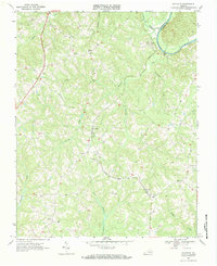
1968 Map of Nathalie
USGS Topo · Published 1984About this map
The Norfolk and Western railway corridor dictates the settlement pattern of this rural Halifax County landscape, connecting small rural hubs like Lennig and Nathalie during the late 1960s. The terrain is defined by a dense network of drainage, where Catawba Creek and Childrey Creek flow toward the prominent bend of the Roanoke River at the Charlotte County line. This area shows a high concentration of community landmarks essential for genealogical research, including numerous small country churches like Traynham Grove Ch and New Shiloh Ch, alongside scattered family and community cemeteries. The presence of a Gaging Sta on the river near Clarkton reflects the era's focus on water management and monitoring. Small, perhaps vanished, locales like Acorn, Birch, and Rabat are clearly marked, providing a detailed look at the dispersed residential footprint of mid-century southern Virginia.
Find a feature on this map
29 named features on this map. Tap any name to fly to it.
Don’t see what you’re looking for? This feature index may not catch every label — zoom into the map to look around manually.
Map Details
Editions of this 1968 Nathalie Map
3 editions found

Other maps of this area

1892 · Lynchburg
USGS Topo · 1:125,000

1892 · Appomattox
USGS Topo · 1:125,000

1947 · Roanoke
USGS Topo · 1:250,000

1953 · Greensboro
USGS Topo · 1:250,000

1954 · Greensboro
USGS Topo · 1:250,000

1954 · Halifax
USGS Topo · 1:62,500

1954 · Riceville
USGS Topo · 1:62,500

1956 · Brookneal
USGS Topo · 1:62,500

1956 · Gladys
USGS Topo · 1:62,500

1959 · Roanoke
USGS Topo · 1:250,000