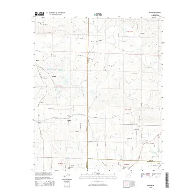
2014 Map of Nathan
USGS Topo · Published 2014About this map
Nathan and Highland anchor a landscape defined by the convergence of Pike, Howard, and Hempstead counties in southwest Arkansas. The terrain is deeply carved by water, with the Muddy Fork and Brushy Cr flowing through a network of small settlements including Briar, Perkins, and Corinth. The map reveals a mix of agricultural and industrial history, from the family-named rural routes like Kizzia Farm Rd and JZ Hale Rd to the industrial presence of the Briar Plant reservoir system. Genealogists will find several burial sites preserved here, such as Mt Pleasant Cem and Corinth Cem. Aviation infrastructure is represented by the Howard County Airport in the south, while the name Mine Rd suggests the local extraction history that shaped the development of these rural communities alongside the banks of the Mine Cr and N Fork Ozan Cr.
Find a feature on this map
105 named features on this map. Tap any name to fly to it.
Don’t see what you’re looking for? This feature index may not catch every label — zoom into the map to look around manually.
Map Details
Editions of this 2014 Nathan Map
This is the sole edition of this map. No revisions or reprints were ever made.
Other maps of this area

1906 · Caddo Gap
USGS Topo · 1:125,000

1951 · Mineral Springs North
USGS Topo · 1:24,000

1951 · Nashville
USGS Topo · 1:24,000

1951 · McCaskill
USGS Topo · 1:24,000

1953 · El Dorado
USGS Topo · 1:250,000

1955 · Little Rock
USGS Topo · 1:250,000

1956 · Little Rock
USGS Topo · 1:250,000

1957 · El Dorado
USGS Topo · 1:250,000

1958 · El Dorado
USGS Topo · 1:250,000

1960 · El Dorado
USGS Topo · 1:250,000