
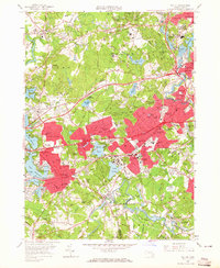
1958 Map of Natick
USGS Topo · Published 1960About this map
The Sudbury River and Charles River frame this mid-century portrait of suburban expansion west of Boston. Major academic institutions define much of the landscape, including the sprawling campuses of Wellesley College, Brandeis University, and Regis College. The infrastructure of the Metropolitan Water Works is visible through the prominent Weston Reservoir and Norumbega Reservoir, alongside the linear paths of several aqueducts. Post-war residential growth is evident in the dense street grids of Lake Forest Park and Cochituate, contrasting with the more established estates near Wellesley Hills and Wellesley Farms. Transportation networks are a focal point, showing the transition from rail to highway as the Boston And Maine and New York Central railroads share the terrain with the Boston-Worcester Turnpike. The map also captures several local landmarks, such as the Stony Brook Res and the Radio Towers (WHDH) near the Charles River bend.
Find a feature on this map
116 named features on this map. Tap any name to fly to it.
Don’t see what you’re looking for? This feature index may not catch every label — zoom into the map to look around manually.
Map Details
Editions of this 1958 Natick Map
2 editions found
Other maps of this area

1886 · Dedham
USGS Topo · 1:62,500

1886 · Framingham
USGS Topo · 1:62,500

1887 · Franklin
USGS Topo · 1:62,500

1889 · Franklin
USGS Topo · 1:62,500

1889 · Framingham
USGS Topo · 1:62,500

1893 · Franklin
USGS Topo · 1:62,500

1893 · Boston
USGS Topo · 1:62,500

1894 · Dedham
USGS Topo · 1:62,500

1894 · Framingham
USGS Topo · 1:62,500

1903 · Boston
USGS Topo · 1:62,500