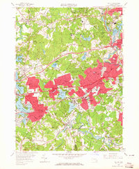
1958 Map of Natick
USGS Topo · Published 1965About this map
The Charles River and Sudbury River define this mid-century portrait of suburban Boston, where established educational institutions and defense facilities occupy a landscape of hills and reservoirs. Several prominent campuses are documented, including Wellesley College, Brandeis University, and the Babson Institute. The region's transport network shows a significant transition, with the Mass Turnpike and Boston-Worcester Turnpike cutting through residential areas while the tracks of the Boston and Albany and New York Central railroads still serve numerous local depots like Cherry Brook Station and Riverside Sta.
Find a feature on this map
146 named features on this map. Tap any name to fly to it.
Don’t see what you’re looking for? This feature index may not catch every label — zoom into the map to look around manually.
Map Details
Editions of this 1958 Natick Map
2 editions found

Other maps of this area

1886 · Dedham
USGS Topo · 1:62,500

1886 · Framingham
USGS Topo · 1:62,500

1887 · Franklin
USGS Topo · 1:62,500

1889 · Franklin
USGS Topo · 1:62,500

1889 · Framingham
USGS Topo · 1:62,500

1893 · Franklin
USGS Topo · 1:62,500

1893 · Boston
USGS Topo · 1:62,500

1894 · Dedham
USGS Topo · 1:62,500

1894 · Framingham
USGS Topo · 1:62,500

1903 · Boston
USGS Topo · 1:62,500