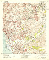
1953 Map of National City
USGS Topo · Published 1955About this map
The San Diego and Arizona Eastern Railway carves through this South Bay landscape during a period of rapid mid-century expansion. The map detail highlights the interface between urban centers like National City and Chula Vista and the still-developing canyons to the east. Infrastructure of the era is prominent, featuring both the National City Airport near the San Diego Bay shoreline and the La Pressa Airport further inland.
Find a feature on this map
78 named features on this map. Tap any name to fly to it.
Don’t see what you’re looking for? This feature index may not catch every label — zoom into the map to look around manually.
Map Details
Editions of this 1953 National City Map
2 editions found
Other maps of this area

1893 · El Cajon
USGS Topo · 1:62,500

1901 · Elcajon
USGS Topo · 1:62,500

1903 · Cuyamaca
USGS Topo · 1:125,000

1903 · La Jolla
USGS Topo · 1:62,500

1903 · Elcajon
USGS Topo · 1:62,500

1904 · San Diego
USGS Topo · 1:62,500

1904 · Southern California Sheet No. 2
USGS Topo · 1:250,000

1930 · La Jolla
USGS Topo · 1:62,500

1930 · San Diego
USGS Topo · 1:62,500

1939 · El Cajon
USGS Topo · 1:62,500