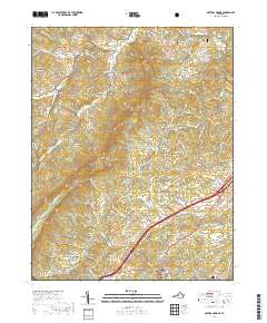
2019 Map of Natural Bridge
USGS Topo · Published 2019About this map
The landmark Natural Bridge and the surrounding rural landscape of Rockbridge County are documented here during the late 2010s. This region is defined by a series of narrow valleys and prominent ridges, including the Short Hills and Buck Hill, where the drainage of Buffalo Cr and its many forks have carved the limestone terrain over millennia. The settlement pattern shows a mix of small hamlets and historic mill sites, such as Red Mills and Murat, connected by a network of winding roads like Zollmans Mill Rd and the Blue Grass Trl.
Find a feature on this map
89 named features on this map. Tap any name to fly to it.
Don’t see what you’re looking for? This feature index may not catch every label — zoom into the map to look around manually.
Map Details
Editions of this 2019 Natural Bridge Map
This is the sole edition of this map. No revisions or reprints were ever made.
Other maps of this area

1894 · Natural Bridge
USGS Topo · 1:125,000

1894 · Lexington
USGS Topo · 1:125,000

1894 · Natural Bridge
USGS Topo · 1:62,500

1907 · Natural Bridge Special
USGS Topo · 1:62,500

1932 · Lexington
USGS Topo · 1:48,000

1935 · Buena Vista
USGS Topo · 1:48,000

1937 · Lexington
USGS Topo · 1:62,500

1939 · Buena Vista
USGS Topo · 1:62,500

1940 · Buena Vista
USGS Topo · 1:62,500

1946 · Millboro
USGS Topo · 1:62,500