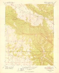
1949 Map of Naturita NW
USGS Topo · Published 1949About this map
The Thunderbolt Mine stands as a primary industrial landmark in this post-war survey of the borderlands between Montrose and San Miguel Counties. The landscape is dominated by the dramatic elevation changes of the Paradox Valley, where the drainage of East Paradox Creek carves through the northern reaches. This era of mapping shows the region prior to extensive modern development, characterized by isolated water sources like Thunderbolt Spring and the high-altitude plateaus of Monogram Mesa.
Find a feature on this map
13 named features on this map. Tap any name to fly to it.
Don’t see what you’re looking for? This feature index may not catch every label — zoom into the map to look around manually.
Map Details
Editions of this 1949 Naturita NW Map
2 editions found

Other maps of this area

1916 · Paradox Valley
USGS Topo · 1:125,000

1922 · Paradox Valley
USGS Topo · 1:125,000

1948 · Bull Canyon
USGS Topo · 1:24,000

1948 · Uravan
USGS Topo · 1:24,000

1948 · Hamm Canyon
USGS Topo · 1:24,000

1948 · Naturita NW
USGS Topo · 1:24,000

1948 · Gypsum Gap
USGS Topo · 1:24,000

1949 · Bull Canyon
USGS Topo · 1:24,000

1949 · Davis Mesa
USGS Topo · 1:24,000

1949 · Gypsum Gap
USGS Topo · 1:24,000