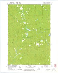
1978 Map of Natzke Camp
USGS Topo · Published 1979About this map
New Wood State Public Hunting Grounds dominates this central Wisconsin landscape, where the legacy of the regional timber industry is written in the names of legacy sites like Natzke Camp and Camp 25. This 1970s survey shows a territory defined by its hydrologic network, with the New Wood River, Copper River, and Wolf Creek draining the forest. The presence of several Old Railroad Grades and an Old RR Grade cutting through the townships of Corning and Harding illustrates the historical transportation infrastructure once used to move logs out of the backwoods. Remote outposts such as Camp Twentysix and Camp 27 are shown alongside natural landmarks like June Lake and Whiskey Bill Creek, offering a detailed view of the area before modern development altered its character as a dedicated conservation and hunting territory.
Find a feature on this map
22 named features on this map. Tap any name to fly to it.
Don’t see what you’re looking for? This feature index may not catch every label — zoom into the map to look around manually.
Map Details
Editions of this 1978 Natzke Camp Map
This is the sole edition of this map. No revisions or reprints were ever made.
Other maps of this area

1902 · Marathon
USGS Topo · 1:125,000

1945 · Rib Lake
USGS Topo · 1:48,000

1947 · Rib Lake
USGS Topo · 1:48,000

1949 · Rib Lake
USGS Topo · 1:48,000

1950 · Spirit Falls
USGS Topo · 1:48,000

1951 · Athens
USGS Topo · 1:48,000

1951 · Hamburg
USGS Topo · 1:48,000

1952 · Spirit Falls
USGS Topo · 1:48,000

1953 · Rice Lake
USGS Topo · 1:250,000

1954 · Iron Mountain
USGS Topo · 1:250,000