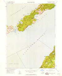
1949 Map of Naushon Island
USGS Topo · Published 1958About this map
Naushon Island and the surrounding Elizabeth Islands appear here in their post-war state, defined by a sparse network of dirt paths like Main Road and North Road. This 1940s landscape is dominated by interior woodlands and a series of kettle ponds, including Money Pond and Westend Pond, which reflect the glacial history of the archipelago. On the island's southeastern shore, the Tarpaulin Cove Lighthouse stands as a critical navigational aid for vessels transiting the deep waters between Buzzards Bay and Vineyard Sound. Across the sound, the map captures a portion of Marthas Vineyard within the town of Chilmark, showing the transition from the Western Hills down to coastal features like Cape Higgon and Harlock Pond. The separation of these landmasses by the tidal currents of Robinsons Hole emphasizes the maritime isolation of the smaller islands during this era.
Find a feature on this map
34 named features on this map. Tap any name to fly to it.
Don’t see what you’re looking for? This feature index may not catch every label — zoom into the map to look around manually.
Map Details
Editions of this 1949 Naushon Island Map
2 editions found
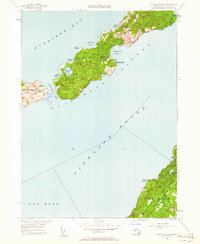
Other maps of this area

1885 · New Bedford
USGS Topo · 1:62,500

1886 · Falmouth
USGS Topo · 1:62,500

1887 · Gay Head
USGS Topo · 1:62,500

1888 · New Bedford
USGS Topo · 1:62,500

1888 · Falmouth
USGS Topo · 1:62,500

1889 · Gay Head
USGS Topo · 1:62,500

1893 · Gay Head
USGS Topo · 1:62,500

1893 · Falmouth
USGS Topo · 1:62,500

1893 · New Bedford
USGS Topo · 1:62,500

1915 · Falmouth
USGS Topo · 1:62,500