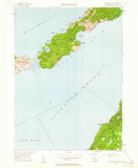
1949 Map of Naushon Island
USGS Topo · Published 1961About this map
Naushon Island and its surrounding archipelago appear here in a post-war revision of topography first recorded in 1941. This portion of the Elizabeth Islands is defined by a dense network of primitive travel routes like Main Road and South Road, connecting the sheltered waters of Tarpaulin Cove to the rugged shoreline of Buzzards Bay. The presence of the Tarpaulin Cove Lighthouse highlights the maritime importance of this passage for vessels transiting Vineyard Sound. To the south, the northern cliffs of Marthas Vineyard rise near Cape Higgon, showing the administrative boundaries of Chilmark and Gay Head. The interior of Naushon is dotted with small freshwater bodies such as Westend Pond and Blaney Pond, surrounded by named groves like Ramshead Woods and Black Woods.
Find a feature on this map
36 named features on this map. Tap any name to fly to it.
Don’t see what you’re looking for? This feature index may not catch every label — zoom into the map to look around manually.
Map Details
Editions of this 1949 Naushon Island Map
2 editions found
Other maps of this area

1885 · New Bedford
USGS Topo · 1:62,500

1886 · Falmouth
USGS Topo · 1:62,500

1887 · Gay Head
USGS Topo · 1:62,500

1888 · New Bedford
USGS Topo · 1:62,500

1888 · Falmouth
USGS Topo · 1:62,500

1889 · Gay Head
USGS Topo · 1:62,500

1893 · Gay Head
USGS Topo · 1:62,500

1893 · Falmouth
USGS Topo · 1:62,500

1893 · New Bedford
USGS Topo · 1:62,500

1915 · Falmouth
USGS Topo · 1:62,500