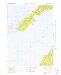
1972 Map of Naushon Island
USGS Topo · Published 1978About this map
Naushon Island dominates this coastal survey, appearing here as an exceptionally private landscape within the Elizabeth Islands. The 1972 data reveals an island defined by dense woodlands like Ramshead Woods and Black Woods, connected by a network of private ways such as Main Road and Western Path. The maritime history of the area is anchored by the Tarpaulin Cove Lighthouse, which stands watch over Tarpaulin Cove, a historic anchorage for sailors transiting Vineyard Sound. Across the water, the northern edge of Marthas Vineyard is visible, including the high bluffs of Gay Head. A small Cem and the French Watering Place suggest the long human occupation of these islands, while the surrounding Buzzards Bay and numerous kettle ponds like Duck Pond illustrate the glacial origins of the local terrain.
Find a feature on this map
43 named features on this map. Tap any name to fly to it.
Don’t see what you’re looking for? This feature index may not catch every label — zoom into the map to look around manually.
Map Details
Editions of this 1972 Naushon Island Map
3 editions found
Other maps of this area

1885 · New Bedford
USGS Topo · 1:62,500

1886 · Falmouth
USGS Topo · 1:62,500

1887 · Gay Head
USGS Topo · 1:62,500

1888 · New Bedford
USGS Topo · 1:62,500

1888 · Falmouth
USGS Topo · 1:62,500

1889 · Gay Head
USGS Topo · 1:62,500

1893 · Gay Head
USGS Topo · 1:62,500

1893 · Falmouth
USGS Topo · 1:62,500

1893 · New Bedford
USGS Topo · 1:62,500

1915 · Falmouth
USGS Topo · 1:62,500