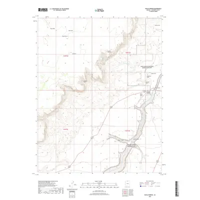
2018 Map of Navajo Bridge
USGS Topo · Published 2018About this map
Marble Canyon and the iconic Navajo Bridge serve as the primary human touchpoints in this 2018 survey of the northern Arizona high desert. The landscape is defined by the deep incision of the Colorado River, which separates the high, arid Paria Plateau and its Sand Hills from the rising elevations of the Vermilion Cliffs. This area marks a critical transition between Glen Canyon National Recreation Area and Grand Canyon National Park, where the river's descent is marked by features like Badger Creek Rapids. Small-scale aviation and tourism infrastructure are evident at the Marble Canyon Airport and along Lees Ferry Rd. Geologic landmarks and named drainage systems, such as Cathedral Wash, Badger Canyon, and Powells Monument, provide a detailed look at the hydrology and landforms of the Coconino County backcountry.
Find a feature on this map
29 named features on this map. Tap any name to fly to it.
Don’t see what you’re looking for? This feature index may not catch every label — zoom into the map to look around manually.
Map Details
Editions of this 2018 Navajo Bridge Map
This is the sole edition of this map. No revisions or reprints were ever made.
Other maps of this area

1886 · Echo Cliffs
USGS Topo · 1:250,000

1891 · Echo Cliffs
USGS Topo · 1:250,000

1951 · Lees Ferry NE
USGS Topo · 1:24,000

1954 · Lees Ferry NW
USGS Topo · 1:24,000

1954 · Emmett Wash NE
USGS Topo · 1:24,000

1954 · Paria Plateau SE
USGS Topo · 1:24,000

1954 · Lees Ferry SE
USGS Topo · 1:24,000

1954 · Lees Ferry SW
USGS Topo · 1:24,000

1954 · Tanner Wash
USGS Topo · 1:62,500

1954 · Emmett Wash
USGS Topo · 1:62,500