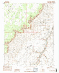
1985 Map of Navajo Bridge
USGS Topo · Published 1985About this map
Navajo Indian Reservation land and the Colorado River corridor define this 1985 survey of Northern Arizona. This landscape is a point of significant geographic transition where the sheer walls of Marble Canyon cut through the high desert floor. The iconic Navajo Bridge provides a vital crossing over the river, linking the remote Vermilion Cliffs to the east and west. Local landmarks like the Vermilion Cliffs Lodge and the small settlement at Marble Canyon serve as rare outposts of human habitation in a region dominated by the Paria Plateau and the Glen Canyon National Recreation Area. Numerous water sources, including Sevenmile Spring and Badger Spring, are noted among the steep drainage systems of Sevenmile Draw and Badger Creek, which terminates at the hazardous Badger Creek Rapids.
Find a feature on this map
34 named features on this map. Tap any name to fly to it.
Don’t see what you’re looking for? This feature index may not catch every label — zoom into the map to look around manually.
Map Details
Editions of this 1985 Navajo Bridge Map
2 editions found
Other maps of this area

1886 · Echo Cliffs
USGS Topo · 1:250,000

1891 · Echo Cliffs
USGS Topo · 1:250,000

1951 · Lees Ferry NE
USGS Topo · 1:24,000

1954 · Lees Ferry NW
USGS Topo · 1:24,000

1954 · Emmett Wash NE
USGS Topo · 1:24,000

1954 · Paria Plateau SE
USGS Topo · 1:24,000

1954 · Lees Ferry SE
USGS Topo · 1:24,000

1954 · Lees Ferry SW
USGS Topo · 1:24,000

1954 · Tanner Wash
USGS Topo · 1:62,500

1954 · Emmett Wash
USGS Topo · 1:62,500