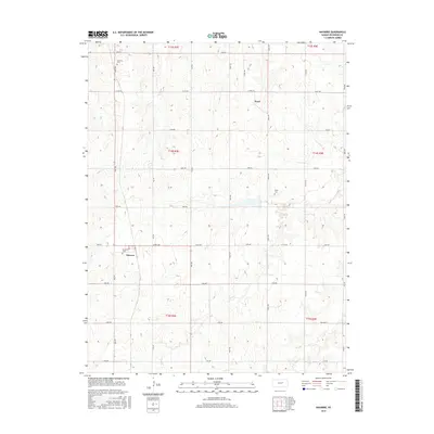
2015 Map of Navarre
USGS Topo · Published 2015About this map
The agrarian landscape of eastern Dickinson County is defined by a grid of section-line roads and the winding drainage of Carry Cr. This Kansas prairie region centers on the small unincorporated settlements of Navarre and Pearl, which serve as quiet hubs for the surrounding farming community. The map preserves the locations of vital local landmarks for genealogists, including the Navarre Cem, Scheiller Cem, and Riffel Cem, each positioned along the edges of cultivated fields and drainage basins like W Br Lyon Cr.
Find a feature on this map
32 named features on this map. Tap any name to fly to it.
Don’t see what you’re looking for? This feature index may not catch every label — zoom into the map to look around manually.
Map Details
Editions of this 2015 Navarre Map
This is the sole edition of this map. No revisions or reprints were ever made.
Other maps of this area

1889 · Abilene
USGS Topo · 1:125,000

1889 · Parkerville
USGS Topo · 1:125,000

1894 · Abilene
USGS Topo · 1:125,000

1894 · Parkerville
USGS Topo · 1:125,000

1955 · Hutchinson
USGS Topo · 1:250,000

1959 · Hutchinson
USGS Topo · 1:250,000

1963 · Abilene SW
USGS Topo · 1:24,000

1964 · Elmo
USGS Topo · 1:24,000
1964 · Chapman
USGS Topo · 1:24,000

1964 · Navarre
USGS Topo · 1:24,000