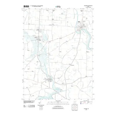
2010 Map of Navarre
USGS Topo · Published 2010About this map
The Tuscarawas River carves through the eastern edge of this landscape, anchoring a corridor of historical development from Navarre south toward Rockville. The river's influence is mirrored by the complex drainage of the Sugar Creek watershed to the west, where the Middle Fork Sugar Creek and South Fork Sugar Creek converge near Beach City. This 2010 topographic record highlights a notable density of rural burial grounds, including the Old Lutheran Cemetery and Saint Clements Cemetery, providing critical spatial data for genealogists tracing Stark County families. Industrial history is etched into the terrain at the Tiger Mine and Fox Mine, while the Beach City Dam and Beach City Lake illustrate modern water management. Smaller crossroads and rail-adjacent communities like Justus, Harmon, and Brewster dot the interior, connected by a network of county roads that reveal the transition from agricultural tracts like Baltzly Farms to concentrated village centers.
Find a feature on this map
101 named features on this map. Tap any name to fly to it.
Don’t see what you’re looking for? This feature index may not catch every label — zoom into the map to look around manually.
Map Details
Editions of this 2010 Navarre Map
This is the sole edition of this map. No revisions or reprints were ever made.
Other maps of this area

1901 · Massillon
USGS Topo · 1:62,500

1901 · Canton
USGS Topo · 1:62,500

1903 · Massillon
USGS Topo · 1:62,500

1903 · Canton
USGS Topo · 1:62,500

1912 · Dover
USGS Topo · 1:62,500

1914 · Navarre
USGS Topo · 1:62,500

1944 · Navarre
USGS Topo · 1:62,500

1944 · Dover
USGS Topo · 1:62,500

1951 · Canton
USGS Topo · 1:250,000

1951 · Bolivar
USGS Topo · 1:24,000