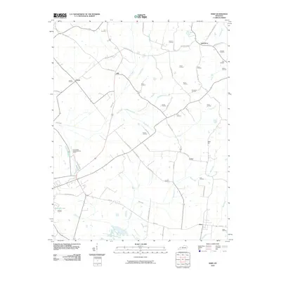
2010 Map of Nebo
USGS Topo · Published 2010About this map
Nebo and Vanderburg anchor this rural landscape in the western coal field region of Kentucky, where a complex network of small waterways and family-named cemeteries defines the local geography. The terrain is notably drained by Slover Creek and Bull Creek, with Balls Hill providing a distinct rise in the eastern portion of the quadrangle. For those researching local lineages, the map is remarkably dense with burial grounds, including the Harralson Cemetery, Winstead Cemetery, and Lisman Cemetery, which serve as permanent markers of the area's early settlement families.
Find a feature on this map
59 named features on this map. Tap any name to fly to it.
Don’t see what you’re looking for? This feature index may not catch every label — zoom into the map to look around manually.
Map Details
Editions of this 2010 Nebo Map
This is the sole edition of this map. No revisions or reprints were ever made.
Other maps of this area

1906 · Sebree
USGS Topo · 1:62,500

1907 · Earlington
USGS Topo · 1:48,000

1907 · Morganfield
USGS Topo · 1:62,500

1909 · Earlington
USGS Topo · 1:62,500

1909 · Providence
USGS Topo · 1:62,500

1949 · Sebree
USGS Topo · 1:24,000

1951 · Dixon
USGS Topo · 1:24,000
1951 · Bordley
USGS Topo · 1:24,000

1951 · Sebree
USGS Topo · 1:24,000

1954 · Evansville
USGS Topo · 1:250,000