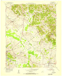
1954 Map of Nebo
USGS Topo · Published 1955About this map
Nebo and Providence anchor the southern portion of this mid-century landscape along the Webster Co Hopkins Co line. The terrain is defined by a dense network of drainage canals and creeks, such as Stover Ditch and Slover Creek, which weave between agricultural tracts and the prominent Balls Hill. Genealogists will find a wealth of family-named landmarks, including the Mooney Cem, McCoy Cem, and Winstead Cem, alongside rural congregations at Hayes Chapel and Stanhope Ch.
Find a feature on this map
46 named features on this map. Tap any name to fly to it.
Don’t see what you’re looking for? This feature index may not catch every label — zoom into the map to look around manually.
Map Details
Editions of this 1954 Nebo Map
This is the sole edition of this map. No revisions or reprints were ever made.
Other maps of this area

1906 · Sebree
USGS Topo · 1:62,500

1907 · Earlington
USGS Topo · 1:48,000

1907 · Morganfield
USGS Topo · 1:62,500

1909 · Earlington
USGS Topo · 1:62,500

1909 · Providence
USGS Topo · 1:62,500

1949 · Sebree
USGS Topo · 1:24,000

1951 · Dixon
USGS Topo · 1:24,000
1951 · Bordley
USGS Topo · 1:24,000

1951 · Sebree
USGS Topo · 1:24,000

1954 · Evansville
USGS Topo · 1:250,000