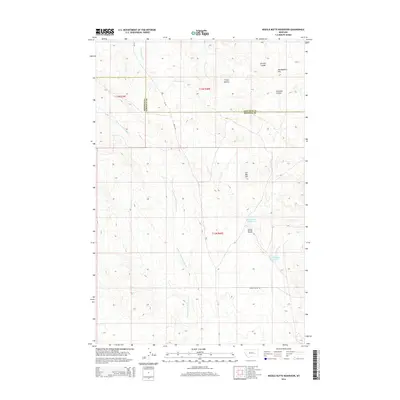
2014 Map of Needle Butte Reservoir
USGS Topo · Published 2014About this map
Needle Butte Reservoir and Round Butte Reservoir provide critical water storage in this high-plains landscape of eastern Montana. Straddling the boundary between Rosebud and Garfield counties, the terrain is defined by a series of prominent elevations including Round Butte, The Big Hill, and the tri-peaked Three Buttes. These landmarks serve as navigational anchors in a region etched by drainage features like Jacques Coulee and Caladine Coulee. The map illustrates a remote grazing or ranching landscape where development is limited to gravel routes such as Road 202 and Needle Butte Rd. Water sources are primary focal points for human activity here, with the E Fork Little Porcupine Cr and Cottonwood Cr winding through the coulees to sustain the local ecosystem. The 2014 survey documents the enduring physical character of the Montana backcountry, from the heights of Montgomery Hill to the essential reservoirs that mark the dry basins.
Find a feature on this map
19 named features on this map. Tap any name to fly to it.
Don’t see what you’re looking for? This feature index may not catch every label — zoom into the map to look around manually.
Map Details
Editions of this 2014 Needle Butte Reservoir Map
This is the sole edition of this map. No revisions or reprints were ever made.
Other maps of this area

1954 · Forsyth
USGS Topo · 1:250,000

1957 · Forsyth
USGS Topo · 1:250,000

1958 · Forsyth
USGS Topo · 1:250,000

1965 · Black Hills
USGS Topo · 1:24,000

1965 · Needle Butte Reservoir
USGS Topo · 1:24,000

1965 · Needle Butte
USGS Topo · 1:24,000
1965 · Christenson Reservoir
USGS Topo · 1:24,000
1965 · Antelope Springs
USGS Topo · 1:24,000

1965 · Stellar Lake
USGS Topo · 1:24,000

1969 · Rudie Coulee
USGS Topo · 1:24,000