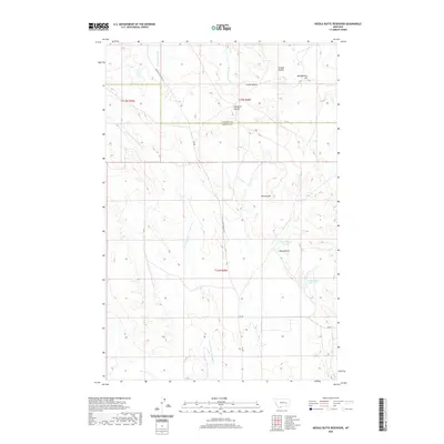
2020 Map of Needle Butte Reservoir
USGS Topo · Published 2020About this map
Round Butte Reservoir and Needle Butte Reservoir provide critical water storage in this high-plains landscape where the Garfield Co Rosebud Co line divides the terrain. The map reveals an intricate drainage system defined by the E Fork Little Porcupine Cr and its tributaries, which carve through a series of named rises including The Big Hill and Three Buttes. This network of coulees and hills dictates the path of local transit, such as Little Porcupine Cr Rd, which follows the contours of the drainage basin. The arrangement of land reflects a late-modern era of ranching and resource management, with prominent landmarks like Montgomery Hill and Jacques Coulee serving as essential reference points in a region where water management and elevation define the human footprint.
Find a feature on this map
21 named features on this map. Tap any name to fly to it.
Don’t see what you’re looking for? This feature index may not catch every label — zoom into the map to look around manually.
Map Details
Editions of this 2020 Needle Butte Reservoir Map
This is the sole edition of this map. No revisions or reprints were ever made.
Other maps of this area

1954 · Forsyth
USGS Topo · 1:250,000

1957 · Forsyth
USGS Topo · 1:250,000

1958 · Forsyth
USGS Topo · 1:250,000

1965 · Black Hills
USGS Topo · 1:24,000

1965 · Needle Butte Reservoir
USGS Topo · 1:24,000

1965 · Needle Butte
USGS Topo · 1:24,000
1965 · Christenson Reservoir
USGS Topo · 1:24,000
1965 · Antelope Springs
USGS Topo · 1:24,000

1965 · Stellar Lake
USGS Topo · 1:24,000

1969 · Rudie Coulee
USGS Topo · 1:24,000