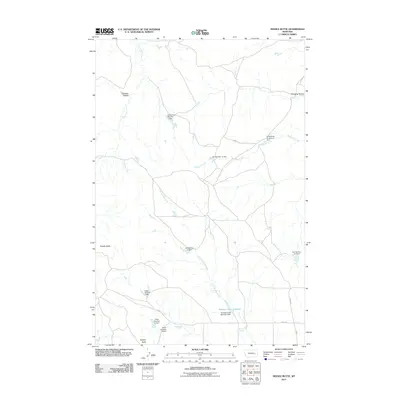
2011 Map of Needle Butte
USGS Topo · Published 2011About this map
Needle Butte and Sunday Butte stand as prominent landmarks in this section of Rosebud County, defining a landscape marked by extensive water management for ranching or local agriculture. The drainage of South Sunday Creek is heavily modified by a series of numbered dams, including the Killen Number 7 Dam, Killen Number 8 Dam, and Killen Number 9 Dam, which collect runoff in this semi-arid terrain. These structures, along with the Lee Number 11 Dam and G Newman Number 6 Dam, illustrate a systematic approach to water storage across the coulees. The southern portion of the map is anchored by the Sunday Creek Reservoir and its associated Sunday Creek Reservoir Dam, while smaller water sources like Sweetser Spring and Lone Tree Creek provide vital points of interest for those studying the local hydrography and land use patterns of eastern Montana.
Find a feature on this map
20 named features on this map. Tap any name to fly to it.
Don’t see what you’re looking for? This feature index may not catch every label — zoom into the map to look around manually.
Map Details
Editions of this 2011 Needle Butte Map
This is the sole edition of this map. No revisions or reprints were ever made.
Other maps of this area

1954 · Forsyth
USGS Topo · 1:250,000

1957 · Forsyth
USGS Topo · 1:250,000

1958 · Forsyth
USGS Topo · 1:250,000

1965 · Black Hills
USGS Topo · 1:24,000

1965 · Needle Butte Reservoir
USGS Topo · 1:24,000

1965 · Needle Butte
USGS Topo · 1:24,000

1965 · Clear Water Reservoir
USGS Topo · 1:24,000
1965 · Christenson Reservoir
USGS Topo · 1:24,000
1965 · Hillside
USGS Topo · 1:24,000

1969 · Van Burton Creek
USGS Topo · 1:24,000