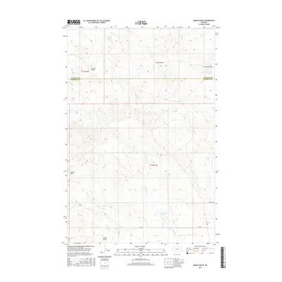
2017 Map of Needle Butte
USGS Topo · Published 2017About this map
Needle Butte and Sunday Butte rise as the primary landmarks in this section of the eastern Montana rangelands, straddling the township lines between Rosebud and Garfield counties. The drainage pattern is defined by ephemeral waterways like Lone Tree Cr and S Sunday Cr, which feed into localized catchments such as the Sunday Cr Reservoir and Clear Water Reservoir. This geography is shaped by the Public Land Survey System, with sections divided into townships t13n r40e and t13n r41e. Small-scale water sources like Sweetser Spring and coulees such as Caladine Coulee suggest the vital importance of water management in this high-plains environment. Human activity is evidenced by a network of rural routes including Killen Rd and Angela Rd N, which navigate the various coulees and creeks that cross this expansive landscape.
Find a feature on this map
18 named features on this map. Tap any name to fly to it.
Don’t see what you’re looking for? This feature index may not catch every label — zoom into the map to look around manually.
Map Details
Editions of this 2017 Needle Butte Map
This is the sole edition of this map. No revisions or reprints were ever made.
Other maps of this area

1954 · Forsyth
USGS Topo · 1:250,000

1957 · Forsyth
USGS Topo · 1:250,000

1958 · Forsyth
USGS Topo · 1:250,000

1965 · Black Hills
USGS Topo · 1:24,000

1965 · Needle Butte Reservoir
USGS Topo · 1:24,000

1965 · Needle Butte
USGS Topo · 1:24,000

1965 · Clear Water Reservoir
USGS Topo · 1:24,000
1965 · Christenson Reservoir
USGS Topo · 1:24,000
1965 · Hillside
USGS Topo · 1:24,000

1969 · Van Burton Creek
USGS Topo · 1:24,000