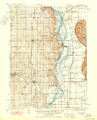
1940 Map of Nehawka
USGS Topo · Published 1950About this map
Youngs Cem and several other rural burial grounds including Mt Pleasant Cem and Scotts Cem dot the landscape of the Nebraska-Iowa borderlands in this mid-century survey. The Missouri River bisects the region, framed by prominent riverine features like Rock Bluff, Queen Hill, and Tobacco Island. The map records a dense network of one-room schools, such as Little Brick Sch No 45, Burr Oak Sch, and Eightmile Grove Sch, illustrating the agrarian school district system before widespread consolidation. Transportation relies heavily on the Missouri Pacific and Chicago Burlington and Quincy railroads, which connect established settlements like Nehawka, Union, and Bartlett. Lowland drainage is highly engineered through complex systems like Waubonsie Creek Ditch and Keg Creek Ditch, reflecting the era's focus on reclaiming fertile floodplains for agriculture.
Find a feature on this map
76 named features on this map. Tap any name to fly to it.
Don’t see what you’re looking for? This feature index may not catch every label — zoom into the map to look around manually.
Map Details
Editions of this 1940 Nehawka Map
3 editions found
Other maps of this area

1893 · Fremont
USGS Topo · 1:125,000

1896 · Fremont
USGS Topo · 1:125,000

1903 · Weeping Water
USGS Topo · 1:125,000

1907 · Nebraska City
USGS Topo · 1:62,500

1929 · Weeping Water
USGS Topo · 1:125,000

1935 · Nehawka
USGS Topo · 1:48,000

1939 · Hamburg
USGS Topo · 1:62,500

1940 · Nehawka
USGS Topo · 1:62,500

1941 · Hamburg
USGS Topo · 1:62,500

1954 · Omaha
USGS Topo · 1:250,000