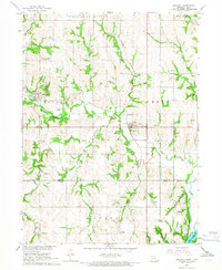
1966 Map of Nehawka
USGS Topo · Published 1968About this map
Nehawka and Union anchor this mid-1960s landscape, where the rugged bluffs of Cass County descend toward the Missouri River. The Missouri Pacific railroad winds through the terrain, following the natural corridors carved by Weeping Water Creek and the South Branch. This survey highlights a rural economy deeply tied to the land, evidenced by numerous Quarries and a Gravel Pit scattered across the hills.
Find a feature on this map
33 named features on this map. Tap any name to fly to it.
Don’t see what you’re looking for? This feature index may not catch every label — zoom into the map to look around manually.
Map Details
Editions of this 1966 Nehawka Map
This is the sole edition of this map. No revisions or reprints were ever made.
Other maps of this area

1903 · Weeping Water
USGS Topo · 1:125,000

1907 · Nebraska City
USGS Topo · 1:62,500

1929 · Weeping Water
USGS Topo · 1:125,000

1935 · Nehawka
USGS Topo · 1:48,000

1940 · Nehawka
USGS Topo · 1:62,500

1955 · Nebraska City
USGS Topo · 1:250,000

1955 · Lincoln
USGS Topo · 1:250,000

1956 · Murray
USGS Topo · 1:24,000

1956 · Rock Bluff
USGS Topo · 1:24,000
1956 · Weeping Water NE
USGS Topo · 1:24,000