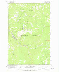
1961 Map of Neihart
USGS Topo · Published 1978About this map
The mining community of Neihart sits at the heart of this 1961 survey, where the silver and lead districts of the Little Belt Mountains are mapped in detail. The settlement follows the narrow corridor of Belt Creek, surrounded by an extensive network of mineral claims and workings that define the local economy. Significant operations such as the Silver Dyke Mine, Broadwater Mines, and the Silver Belt Mine are situated on the steep slopes of Pioneer Ridge and Poverty Ridge. The map illustrates the industrial footprint of the era, including Tailing Ponds and a Quarry, as well as the infrastructure required to support the mountain camps.
Find a feature on this map
50 named features on this map. Tap any name to fly to it.
Don’t see what you’re looking for? This feature index may not catch every label — zoom into the map to look around manually.
Map Details
Editions of this 1961 Neihart Map
2 editions found
Other maps of this area

1886 · Little Belt Mts.
USGS Topo · 1:250,000

1890 · Fort Benton
USGS Topo · 1:250,000

1892 · Fort Benton
USGS Topo · 1:250,000

1894 · Little Belt Mts.
USGS Topo · 1:250,000

1897 · Fort Benton
USGS Topo · 1:250,000

1897 · Little Belt Mts.
USGS Topo · 1:250,000

1898 · Little Belt Mts.
USGS Topo · 1:250,000

1902 · Little Belt Mts.
USGS Topo · 1:250,000

1948 · White Sulphur Springs
USGS Topo · 1:250,000

1954 · Great Falls
USGS Topo · 1:250,000