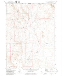
1979 Map of Nellie Spring Mtn
USGS Topo · Published 1979About this map
Nellie Spring Mountain dominates the southwestern corner of this high-desert landscape in Washoe County, where a network of seasonal water sources and rugged trails define the local geography. The settlement at Grassy Ranch serves as a lone human outpost near the intersection of Grassy Canyon and the surrounding tablelands. To the northeast, the High Rock Canyon PACK TRAIL winds through High Rock Canyon, following a path past Canyon Spring. This 1970s survey illustrates a region shaped by ranching and small-scale exploration, evidenced by scattered Prospects and water management features like Argon Res and the Lower Indian Spring. Numerous Jeep Trail routes crisscross the terrain, connecting various unnamed springs that have long been vital for survival and movement through this corner of Nevada.
Find a feature on this map
18 named features on this map. Tap any name to fly to it.
Don’t see what you’re looking for? This feature index may not catch every label — zoom into the map to look around manually.
Map Details
Editions of this 1979 Nellie Spring Mtn Map
2 editions found
Other maps of this area

1889 · Long Valley
USGS Topo · 1:250,000

1954 · Vya
USGS Topo · 1:250,000

1958 · Vya
USGS Topo · 1:250,000

1962 · Vya
USGS Topo · 1:250,000

1966 · Nut Mountain
USGS Topo · 1:24,000

1966 · Massacre Creek
USGS Topo · 1:24,000

1966 · Painted Point
USGS Topo · 1:24,000

1972 · Mahogany Mtn
USGS Topo · 1:24,000
1972 · Yellow Hills West
USGS Topo · 1:24,000

1978 · Hart Mountain
USGS Topo · 1:24,000