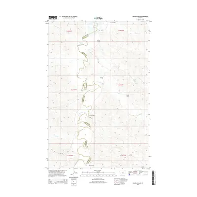
2014 Map of Nelson Coulee
USGS Topo · Published 2014About this map
The Musselshell River defines the winding boundary between Petroleum and Garfield counties in this central Montana landscape. This 2014 survey captures a sparsely populated region characterized by dramatic drainage systems, including Nelson Coulee, Sherman Coulee, and Powell Coulee. These features carve through the high plains, funneling seasonal waters toward the river valley. Sparse human infrastructure is confined to few improved routes like Rivendell Rd and Dunn Ridge Rd, alongside a network of trails. Local history is anchored at the isolated Coon Cem, while the presence of School Section Spring and named meadows like The Willows highlight the critical importance of water sources in this arid ranching country. Tributaries such as Lodgepole Cr and Dovetail Cr further illustrate the intricate watershed that sustains the local environment.
Find a feature on this map
25 named features on this map. Tap any name to fly to it.
Don’t see what you’re looking for? This feature index may not catch every label — zoom into the map to look around manually.
Map Details
Editions of this 2014 Nelson Coulee Map
This is the sole edition of this map. No revisions or reprints were ever made.
Other maps of this area

1954 · Jordan
USGS Topo · 1:250,000

1954 · Lewistown
USGS Topo · 1:250,000

1956 · Jordan
USGS Topo · 1:250,000

1958 · Jordan
USGS Topo · 1:250,000

1959 · Lewistown
USGS Topo · 1:250,000

1964 · Jordan
USGS Topo · 1:250,000

1965 · Germaine Coulee East
USGS Topo · 1:24,000

1965 · Germaine Coulee West
USGS Topo · 1:24,000
1965 · Weingart Place
USGS Topo · 1:24,000

1967 · Nelson Coulee
USGS Topo · 1:24,000