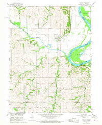
1966 Map of Nemaha
USGS Topo · Published 1968About this map
The Little Nemaha River meanders toward its confluence with the Missouri River in this mid-1960s study of the Nebraska-Missouri border. The settlement of Nemaha serves as the focal point, situated near a complex network of transportation routes including the Chicago Burlington and Quincy railroad and an Old Railroad Grade. This era shows a landscape deeply shaped by both agriculture and industry, with several Quarries and a Quarry dotting the bluffs above the riverbanks.
Find a feature on this map
27 named features on this map. Tap any name to fly to it.
Don’t see what you’re looking for? This feature index may not catch every label — zoom into the map to look around manually.
Map Details
Editions of this 1966 Nemaha Map
2 editions found
Other maps of this area

1915 · Falls City
USGS Topo · 1:62,500

1915 · Nemaha
USGS Topo · 1:62,500

1915 · Howe
USGS Topo · 1:62,500

1916 · Humboldt
USGS Topo · 1:62,500

1939 · Nemaha
USGS Topo · 1:62,500

1949 · Nemaha
USGS Topo · 1:62,500

1955 · Nebraska City
USGS Topo · 1:250,000

1957 · Nebraska City
USGS Topo · 1:250,000

1958 · Nebraska City
USGS Topo · 1:250,000
1965 · Dawson
USGS Topo · 1:24,000