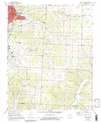
1972 Map of Neosho East
USGS Topo · Published 1984About this map
Neosho serves as the focal point for this eastern Newton County survey, showing a landscape defined by civic institutions and natural springs. The western edge of the map features the National Fish Hatchery and several educational landmarks, including Crowder College and Big Spring Sch. Rural life and communal history are preserved in the locations of numerous family and fraternal burial grounds such as the IOOF Cem, Elm Spring Cem, and Maness Cem.
Find a feature on this map
44 named features on this map. Tap any name to fly to it.
Don’t see what you’re looking for? This feature index may not catch every label — zoom into the map to look around manually.
Map Details
Editions of this 1972 Neosho East Map
3 editions found
Other maps of this area

1916 · Neosho
USGS Topo · 1:62,500

1940 · Noel
USGS Topo · 1:62,500

1941 · Rocky Comfort
USGS Topo · 1:62,500

1943 · Ritchey
USGS Topo · 1:62,500

1943 · Noel
USGS Topo · 1:62,500

1943 · Rocky Comfort
USGS Topo · 1:62,500

1954 · Tulsa
USGS Topo · 1:250,000

1958 · Tulsa
USGS Topo · 1:250,000

1963 · Tulsa
USGS Topo · 1:250,000
1972 · Granby
USGS Topo · 1:24,000