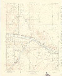
1904 Map of Nepesta
USGS Topo · Published 1906About this map
The Arkansas River corridor serves as the industrial and agricultural lifeline for this portion of the Colorado plains at the turn of the century. Parallel rail lines, the Atchison Topeka and Santa Fe R. R. and the Missouri Pacific R. R., flank the river, supporting a string of settlements including Vineland, Avondale, and Boone. Irrigation infrastructure is highly developed, with the Excelsior Ditch and Highland Canal drawing water from the river to support local agriculture and the Bessemer Reservoir. Away from the river valley, the landscape is defined by vast cattle operations like the Skinner and Tabor Ranch and Tolle Ranch. To the south, the Huerfano River flows past the Hooker Hills and the remote settlement of Undercliffe, illustrating the early ranching footprint in Pueblo and Otero Counties.
Find a feature on this map
38 named features on this map. Tap any name to fly to it.
Don’t see what you’re looking for? This feature index may not catch every label — zoom into the map to look around manually.
Map Details
Editions of this 1904 Nepesta Map
3 editions found

Other maps of this area

1889 · Sanborn
USGS Topo · 1:125,000

1891 · Walsenburg
USGS Topo · 1:125,000

1891 · Sanborn
USGS Topo · 1:125,000

1891 · Catlin
USGS Topo · 1:125,000

1891 · Pueblo
USGS Topo · 1:125,000

1891 · Timpas
USGS Topo · 1:125,000

1891 · Nepesta
USGS Topo · 1:125,000

1891 · Apishapa
USGS Topo · 1:125,000

1893 · Nepesta
USGS Topo · 1:125,000

1893 · Sanborn
USGS Topo · 1:125,000