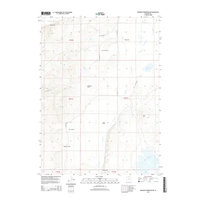
2014 Map of Neponset Reservoir NW
USGS Topo · Published 2014About this map
Neponset Reservoir and the drainage of Saleratus Creek dominate this high-desert landscape in Rich County. The area is characterized by a network of ranching roads and canyons, including Meachum Canyon, Home Canyon, and several hollows like Ashton Hollow and Cabin Hollow. The presence of water sources such as Eagle Springs and Blue Grass Pond amidst the dry terrain highlights the critical importance of water management in this part of Utah. Man-made infrastructure, such as the Co-Op Ditch and the S Main Ranch Way, underscores the enduring ranching economy. Prominent landforms like Red Hill and the broad Big Meadow provide geographical context for the various grazing lands and corridors that have shaped the local history of land use in the early twenty-first century.
Find a feature on this map
27 named features on this map. Tap any name to fly to it.
Don’t see what you’re looking for? This feature index may not catch every label — zoom into the map to look around manually.
Map Details
Editions of this 2014 Neponset Reservoir NW Map
This is the sole edition of this map. No revisions or reprints were ever made.
Other maps of this area

1912 · Randolph
USGS Topo · 1:125,000

1954 · Ogden
USGS Topo · 1:250,000

1958 · Ogden
USGS Topo · 1:250,000

1960 · Ogden
USGS Topo · 1:250,000

1968 · Woodruff
USGS Topo · 1:24,000

1968 · Mc Kay Hollow
USGS Topo · 1:24,000

1968 · Neponset Reservoir NE
USGS Topo · 1:24,000

1968 · Meachum Ridge
USGS Topo · 1:24,000

1968 · Peck Canyon
USGS Topo · 1:24,000
1968 · Woodruff Narrows
USGS Topo · 1:24,000