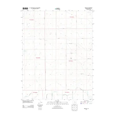
2013 Map of Nero Hill
USGS Topo · Published 2013About this map
Nero Hill rises above a landscape defined by an intricate network of early 21st-century water management systems in Crowley County. The southern portion of this area is dominated by the Colorado Canal and its associated distribution channels, including the Peister Lateral, Swink Lateral, and W Brush Lateral. These features highlight the importance of irrigation and water control in the arid High Plains environment, where natural drainages like Bob Cr and Breckenridge Cr are supplemented by man-made structures like the Cudahy Reservoir. The map follows a rigid section-line grid, with local access provided by a series of numbered roads such as CO Road R and CO Road K. This survey provides a clear look at the intersection of natural topography and agricultural engineering, showing how the land was partitioned and watered decades after the initial settlement of the region.
Find a feature on this map
32 named features on this map. Tap any name to fly to it.
Don’t see what you’re looking for? This feature index may not catch every label — zoom into the map to look around manually.
Map Details
Editions of this 2013 Nero Hill Map
This is the sole edition of this map. No revisions or reprints were ever made.
Other maps of this area

1891 · Catlin
USGS Topo · 1:125,000

1893 · Catlin
USGS Topo · 1:125,000

1954 · Olney Springs
USGS Topo · 1:24,000

1954 · Sugar City
USGS Topo · 1:24,000

1954 · Ordway
USGS Topo · 1:24,000

1954 · Lamar
USGS Topo · 1:250,000

1958 · Lamar
USGS Topo · 1:250,000
1977 · Antelope Mesa
USGS Topo · 1:24,000
1977 · Box Springs
USGS Topo · 1:24,000
1978 · Ninemile Spring
USGS Topo · 1:24,000