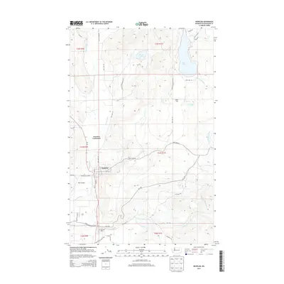
2014 Map of Nespelem
USGS Topo · Published 2014About this map
The Colville Indian Agency serves as a central hub in this section of the Colville Indian Reservation, where the landscape is defined by the winding paths of the Nespelem River and the Little Nespelem River. The town of Nespelem is clearly laid out with its grid of streets, including A St through D St, situated just south of the Nespelem Community. This area represents a vital administrative and residential core for the reservation, bounded by distinctive geological features like Kroll Canyon and the broad expanse of Owhi Flat. Water is a primary feature of the geography, with Owhi Lake dominating the northeastern corner and numerous smaller tributaries such as Joe Moses Cr and Poween Cr draining the surrounding uplands. The road network, largely comprised of Bureau of Indian Affairs routes like BIA 13 Rd and Cache Creek Rd, illustrates the connectivity between these highland lakes and the river valley settlements.
Find a feature on this map
47 named features on this map. Tap any name to fly to it.
Don’t see what you’re looking for? This feature index may not catch every label — zoom into the map to look around manually.
Map Details
Editions of this 2014 Nespelem Map
This is the sole edition of this map. No revisions or reprints were ever made.
Other maps of this area

1950 · Nespelem
USGS Topo · 1:62,500

1950 · Alameda Flat
USGS Topo · 1:62,500

1952 · Alameda Flat
USGS Topo · 1:62,500

1952 · Disautel
USGS Topo · 1:62,500

1953 · Bald Knob
USGS Topo · 1:62,500

1954 · Okanogan
USGS Topo · 1:250,000

1958 · Okanogan
USGS Topo · 1:250,000
1983 · Omak
USGS Topo · 1:100,000

1984 · Nespelem
USGS Topo · 1:100,000

1986 · Central Peak
USGS Topo · 1:24,000