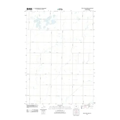
2012 Map of Ness Chain Lakes
USGS Topo · Published 2012About this map
Redstone Cem lies near the geographic center of this Hanson County landscape, offering a focal point for genealogical research in Jasper Township. The surrounding terrain is defined by a series of glacial depressions and waterways, most notably the Ness Chain Lake system and the neighboring School Section Lakes. Further east, Stone House Lake and Lake Leo sit among the section lines, while the wandering path of Rock Cr cuts across the township's grid. The 2012 survey illustrates a classic South Dakota agricultural layout, where a disciplined network of numbered avenues and streets—such as 419th Ave and 246th St—brackets the natural hydrology of the James River valley periphery.
Find a feature on this map
22 named features on this map. Tap any name to fly to it.
Don’t see what you’re looking for? This feature index may not catch every label — zoom into the map to look around manually.
Map Details
Editions of this 2012 Ness Chain Lakes Map
This is the sole edition of this map. No revisions or reprints were ever made.
Other maps of this area

1899 · Alexandria
USGS Topo · 1:125,000

1955 · Sioux Falls
USGS Topo · 1:250,000

1957 · Alexandria
USGS Topo · 1:24,000

1957 · Farwell NW
USGS Topo · 1:24,000

1957 · Riverside
USGS Topo · 1:24,000

1957 · Farwell
USGS Topo · 1:24,000

1958 · Sioux Falls
USGS Topo · 1:250,000
1973 · Morris Lake
USGS Topo · 1:24,000

1973 · Ness Chain Lakes
USGS Topo · 1:24,000

1973 · Farmer
USGS Topo · 1:24,000