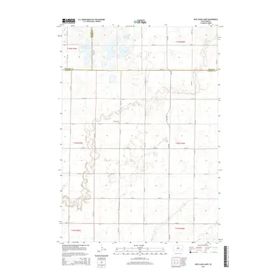
2015 Map of Ness Chain Lakes
USGS Topo · Published 2015About this map
Ness Chain Lake and the surrounding prairie wetlands form the heart of this East River landscape, where the borders of Sanborn, Miner, and Hanson Counties converge. The 2015 survey reveals a terrain defined by glacial depressions and seasonal water bodies, including Stone House Lake, Lake Leo, and the scattered School Section Lakes. This area of South Dakota maintains a rigid section-line road grid, with routes like 243rd St and 419th Ave cutting through the open country.
Find a feature on this map
31 named features on this map. Tap any name to fly to it.
Don’t see what you’re looking for? This feature index may not catch every label — zoom into the map to look around manually.
Map Details
Editions of this 2015 Ness Chain Lakes Map
This is the sole edition of this map. No revisions or reprints were ever made.
Other maps of this area

1899 · Alexandria
USGS Topo · 1:125,000

1955 · Sioux Falls
USGS Topo · 1:250,000

1957 · Alexandria
USGS Topo · 1:24,000

1957 · Farwell NW
USGS Topo · 1:24,000

1957 · Riverside
USGS Topo · 1:24,000

1957 · Farwell
USGS Topo · 1:24,000

1958 · Sioux Falls
USGS Topo · 1:250,000
1973 · Morris Lake
USGS Topo · 1:24,000

1973 · Ness Chain Lakes
USGS Topo · 1:24,000

1973 · Farmer
USGS Topo · 1:24,000