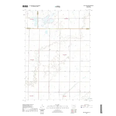
2017 Map of Ness Chain Lakes
USGS Topo · Published 2017About this map
Redstone Cem lies near the intersection of 246th St and Co Rd 4, serving as a central point of local history in this South Dakota prairie landscape. The area is defined by a series of glacial depressions and water bodies, most notably the namesake Ness Chain Lake and the nearby School Section Lakes. These hydrologic features are connected by the winding path of Rock Cr, which meanders southeast toward the boundary of Hanson Co. The map reveals a strictly regulated section-line road network, such as 420th Ave and 244th St, that delineates the agricultural tracts of the region. Local drainage patterns are further marked by Stone House Lake to the north and the seasonal flows of Johnson Creek in the southern reaches, illustrating the subtle topography of the Great Plains.
Find a feature on this map
32 named features on this map. Tap any name to fly to it.
Don’t see what you’re looking for? This feature index may not catch every label — zoom into the map to look around manually.
Map Details
Editions of this 2017 Ness Chain Lakes Map
This is the sole edition of this map. No revisions or reprints were ever made.
Other maps of this area

1899 · Alexandria
USGS Topo · 1:125,000

1955 · Sioux Falls
USGS Topo · 1:250,000

1957 · Alexandria
USGS Topo · 1:24,000

1957 · Farwell NW
USGS Topo · 1:24,000

1957 · Riverside
USGS Topo · 1:24,000

1957 · Farwell
USGS Topo · 1:24,000

1958 · Sioux Falls
USGS Topo · 1:250,000
1973 · Morris Lake
USGS Topo · 1:24,000

1973 · Ness Chain Lakes
USGS Topo · 1:24,000

1973 · Farmer
USGS Topo · 1:24,000