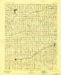
1894 Map of Ness
USGS Topo · Published 1924About this map
Ness City and Jetmore anchor this late 19th-century survey of western Kansas, where the prairie landscape is defined by the rigid grid of townships and the lifeblood of its waterways. The Atchison Topeka and Santa Fe Railroad cuts through the northern and southern sectors, establishing a corridor for development that connected small hubs like Bazine and Marena to wider markets. Away from the rails, the map preserves the locations of early outposts like Schoharie P.O. and Sidney, which were critical nodes for homesteaders in the 1880s.
Find a feature on this map
37 named features on this map. Tap any name to fly to it.
Don’t see what you’re looking for? This feature index may not catch every label — zoom into the map to look around manually.
Map Details
Editions of this 1894 Ness Map
5 editions found

Other maps of this area

1889 · Larned
USGS Topo · 1:125,000

1889 · Kinsley
USGS Topo · 1:125,000

1891 · Larned
USGS Topo · 1:125,000

1892 · Ness
USGS Topo · 1:125,000

1892 · Kinsley
USGS Topo · 1:125,000

1892 · Dodge
USGS Topo · 1:125,000

1892 · Spearville
USGS Topo · 1:125,000

1893 · Ellis
USGS Topo · 1:125,000

1894 · Spearville
USGS Topo · 1:125,000

1894 · Kinsley
USGS Topo · 1:125,000