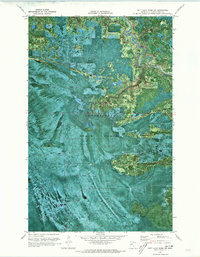
1970 Map of Nett Lake River SW
USGS Topo · Published 1973About this map
The Little Fork River meanders through the northern reaches of this orthophotomap, cutting a distinct path through the dense vegetation of the Koochiching State Forest. Produced by the U.S. Geological Survey and the State of Minnesota Department of Administration, this 1970 study uses aerial imagery to document a landscape defined by its seasonal access and timber resources. The presence of the Winter Road Trail and multiple stretches of the Winter Trail highlights the importance of frozen ground for navigating this northern terrain. These routes, visible as straight clearings and winding paths against the forest canopy, provided essential corridors for logging and transport during the winter months when the marshy ground was otherwise impassable. The imagery captures the transition between managed forest areas and the natural drainage patterns of the river valley before the modern era of permanent road development.
Find a feature on this map
5 named features on this map. Tap any name to fly to it.
Don’t see what you’re looking for? This feature index may not catch every label — zoom into the map to look around manually.
Map Details
Editions of this 1970 Nett Lake River SW Map
This is the sole edition of this map. No revisions or reprints were ever made.
Other maps of this area

1919 · M
USGS Topo · 1:62,500

1954 · Hibbing
USGS Topo · 1:250,000

1954 · International Falls
USGS Topo · 1:250,000

1957 · Hibbing
USGS Topo · 1:250,000

1957 · International Falls
USGS Topo · 1:250,000

1958 · International Falls
USGS Topo · 1:250,000

1958 · Hibbing
USGS Topo · 1:250,000

1964 · Hibbing
USGS Topo · 1:250,000

1970 · Johnson Landing SE
USGS Topo · 1:24,000

1970 · Nett Lake River SE
USGS Topo · 1:24,000