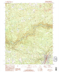
1995 Map of Nevada City
USGS Topo · Published 1995About this map
The San Juan Ridge landscape of the 1990s reveals a region profoundly shaped by its 19th-century hydraulic mining heritage. This era is visible through extensive earthworks and remnants like the Cherokee Diggings, Sebastopol Diggings, and North Columbia Diggings. The South Yuba River cuts through the center of the sheet, bordered by the South Yuba River State Park Unit, illustrating the late-20th-century shift toward conservation and recreation in a previously industrial landscape.
Find a feature on this map
50 named features on this map. Tap any name to fly to it.
Don’t see what you’re looking for? This feature index may not catch every label — zoom into the map to look around manually.
Map Details
Editions of this 1995 Nevada City Map
2 editions found
Other maps of this area

1888 · Smartsville
USGS Topo · 1:125,000

1891 · Colfax
USGS Topo · 1:125,000

1891 · Smartsville
USGS Topo · 1:125,000

1892 · Smartsville
USGS Topo · 1:125,000

1892 · Colfax
USGS Topo · 1:125,000

1894 · Colfax
USGS Topo · 1:125,000

1894 · Smartsville
USGS Topo · 1:125,000

1895 · Smartsville
USGS Topo · 1:125,000

1898 · Colfax
USGS Topo · 1:125,000

1900 · Colfax
USGS Topo · 1:125,000