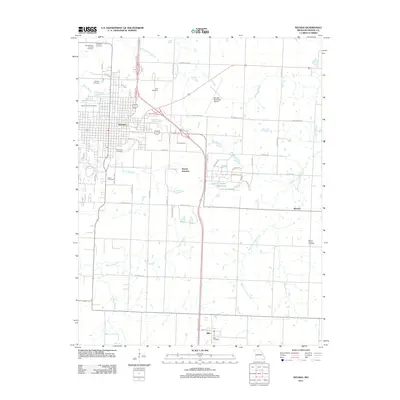
2011 Map of Nevada
USGS Topo · Published 2011About this map
Nevada serves as the focal point of this 2011 survey, showing the Vernon County seat during a period of modern expansion. The landscape is marked by a significant concentration of burial grounds, including the Nevada State Hospital Cemetery, Mount Calvary Cemetery, and Deepwood Cemetery, which provide critical points of reference for local genealogists. Outside the city center, the terrain transitions into a drainage network defined by West Fork Clear Creek and the Charles Vincent Reservoir, alongside the small outlying settlements of Bristow and Milo to the south.
Find a feature on this map
58 named features on this map. Tap any name to fly to it.
Don’t see what you’re looking for? This feature index may not catch every label — zoom into the map to look around manually.
Map Details
Editions of this 2011 Nevada Map
This is the sole edition of this map. No revisions or reprints were ever made.
Other maps of this area

1886 · Nevada
USGS Topo · 1:125,000

1894 · Nevada
USGS Topo · 1:125,000

1933 · Camp Clark
USGS Topo · 1:24,000

1938 · Metz
USGS Topo · 1:24,000

1938 · Horton
USGS Topo · 1:24,000

1939 · Metz
USGS Topo · 1:24,000

1939 · Horton
USGS Topo · 1:24,000

1939 · Dederick
USGS Topo · 1:24,000
1939 · Harwood
USGS Topo · 1:24,000

1939 · Moundville
USGS Topo · 1:24,000