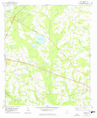
1978 Map of Nevils
USGS Topo · Published 1978About this map
The coastal plain landscape of south Georgia is defined here by the intricate drainage systems of Lotts Creek and its many tributaries. In the late 1970s, this rural area near the border of Bulloch Co and Evans Co remained a patchwork of woodland and cleared fields, connected by a network of local churches that anchored the community. Notable among these are Ephesus Old Line Ch and New Corent Ch, alongside several cemeteries that offer significant value for genealogical research.
Find a feature on this map
24 named features on this map. Tap any name to fly to it.
Don’t see what you’re looking for? This feature index may not catch every label — zoom into the map to look around manually.
Map Details
Editions of this 1978 Nevils Map
This is the sole edition of this map. No revisions or reprints were ever made.
Other maps of this area

1919 · Claxton
USGS Topo · 1:62,500

1920 · Pembroke
USGS Topo · 1:62,500

1920 · Statesboro
USGS Topo · 1:62,500

1921 · Brooklet
USGS Topo · 1:62,500

1943 · Brooklet
USGS Topo · 1:62,500

1943 · Statesboro
USGS Topo · 1:62,500

1944 · Claxton
USGS Topo · 1:62,500

1947 · Savannah
USGS Topo · 1:250,000

1948 · Savannah
USGS Topo · 1:250,000

1948 · Pembroke
USGS Topo · 1:62,500