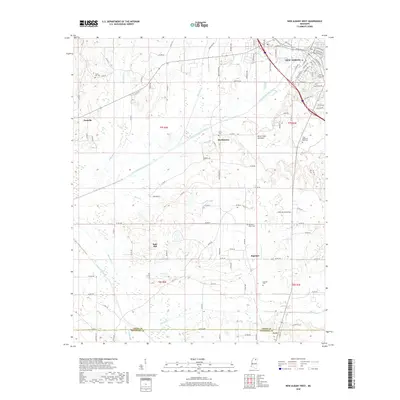
2018 Map of New Albany West
USGS Topo · Published 2018About this map
The Little Tallahatchie River and its wide alluvial basin at King Creek Bottoms dominate the topography of this Union County landscape. To the north, the western suburbs of New Albany stretch toward the river, while the smaller settlements of Martintown and Poolville occupy the higher ground between creek drainages. The southern portion of the map follows the historic boundary between Union Co and Pontotoc Co, where the community of Ingomar sits near the headwaters of Jones Cr.
Find a feature on this map
112 named features on this map. Tap any name to fly to it.
Don’t see what you’re looking for? This feature index may not catch every label — zoom into the map to look around manually.
Map Details
Editions of this 2018 New Albany West Map
This is the sole edition of this map. No revisions or reprints were ever made.
Other maps of this area

1949 · New Albany
USGS Topo · 1:62,500

1951 · New Albany
USGS Topo · 1:62,500

1955 · Ripley
USGS Topo · 1:62,500

1955 · Sherman
USGS Topo · 1:62,500

1955 · Blue Mountain
USGS Topo · 1:62,500

1956 · Tupelo
USGS Topo · 1:250,000

1958 · Tupelo
USGS Topo · 1:250,000

1980 · Northwest Pontotoc
USGS Topo · 1:24,000
1980 · Thaxton
USGS Topo · 1:24,000

1980 · New Albany West
USGS Topo · 1:24,000