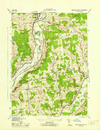
1945 Map of New Berlin South
USGS Topo · Published 1945About this map
The Unadilla River forms a natural boundary between Chenango and Otsego counties, anchoring a valley where the New York Ontario and Western RR tracks parallel the water. This mid-1940s survey illustrates a rural landscape defined by decentralized communities and small-scale infrastructure, including scattered educational sites like School No. 8 and Wheeler Sch. The terrain rises sharply from the riverbanks toward Pittsfield Mountain, with numerous ponds such as Hunts Pond and Allens Pond dotting the uplands.
Find a feature on this map
38 named features on this map. Tap any name to fly to it.
Don’t see what you’re looking for? This feature index may not catch every label — zoom into the map to look around manually.
Map Details
Editions of this 1945 New Berlin South Map
This is the sole edition of this map. No revisions or reprints were ever made.
Other maps of this area

1910 · Hartwick
USGS Topo · 1:62,500

1910 · New Berlin
USGS Topo · 1:62,500

1912 · New Berlin
USGS Topo · 1:62,500

1912 · Hartwick
USGS Topo · 1:62,500

1915 · Oneonta
USGS Topo · 1:62,500

1915 · Unadilla
USGS Topo · 1:62,500

1918 · Unadilla
USGS Topo · 1:62,500

1918 · Oneonta
USGS Topo · 1:62,500

1943 · New Berlin North
USGS Topo · 1:24,000

1943 · New Berlin South
USGS Topo · 1:24,000