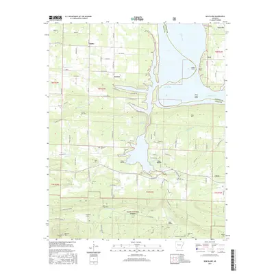
2017 Map of New Blaine
USGS Topo · Published 2017About this map
New Blaine and the surrounding Logan County countryside are defined by the wide expanse of Lake Dardanelle and the winding course of the Arkansas River. This modern survey illustrates a landscape where the river’s influence is paramount, creating landforms like Shoal Creek Narrows and Shoal Creek Island. Historically significant sites for genealogists are scattered throughout the region, including Saint Scholastica Cem near the town of Dublin and several smaller family burial grounds like Frietsche Cem and Tritt Cem.
Find a feature on this map
113 named features on this map. Tap any name to fly to it.
Don’t see what you’re looking for? This feature index may not catch every label — zoom into the map to look around manually.
Map Details
Editions of this 2017 New Blaine Map
This is the sole edition of this map. No revisions or reprints were ever made.
Other maps of this area

1879 · Mountain Home
USGS Topo · 1:62,500

1887 · Magazine Mountain #1
USGS Topo · 1:62,500

1887 · Magazine Mountain #4
USGS Topo · 1:62,500

1887 · Magazine Mountain
USGS Topo · 1:62,500

1888 · Dardanelle #2
USGS Topo · 1:62,500

1888 · Dardanelle #3
USGS Topo · 1:62,500

1890 · Magazine Mountain
USGS Topo · 1:125,000

1890 · Dardanelle
USGS Topo · 1:125,000

1956 · Russellville
USGS Topo · 1:250,000
1961 · Hartman
USGS Topo · 1:24,000