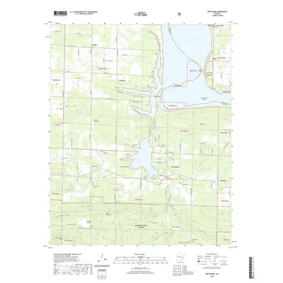
2020 Map of New Blaine
USGS Topo · Published 2020About this map
Ozark National Forest lands dominate the southern landscape of this Arkansas River Valley region, where the heights of Huckleberry Mtn and Pine Ridge Mtn overlook the lowlands of Egypt Hollow. The northern portion of the map is defined by the waters of Lake Dardanelle and the Shoal Creek Narrows, creating a complex shoreline that shapes the local road network. Settlements like New Blaine and Dublin serve as hubs for the surrounding rural communities. Genealogists will find several burial sites preserved across the terrain, including Saint Scholastica Cem and the McReynolds Cem located near Moore Mtn. The map records a transition from the protected forest ridges down to the agricultural and recreational lands surrounding the river and its numerous tributaries like Big Shoal Creek and Little Shoal Cr.
Find a feature on this map
110 named features on this map. Tap any name to fly to it.
Don’t see what you’re looking for? This feature index may not catch every label — zoom into the map to look around manually.
Map Details
Editions of this 2020 New Blaine Map
This is the sole edition of this map. No revisions or reprints were ever made.
Other maps of this area

1879 · Mountain Home
USGS Topo · 1:62,500

1887 · Magazine Mountain #1
USGS Topo · 1:62,500

1887 · Magazine Mountain #4
USGS Topo · 1:62,500

1887 · Magazine Mountain
USGS Topo · 1:62,500

1888 · Dardanelle #2
USGS Topo · 1:62,500

1888 · Dardanelle #3
USGS Topo · 1:62,500

1890 · Magazine Mountain
USGS Topo · 1:125,000

1890 · Dardanelle
USGS Topo · 1:125,000

1956 · Russellville
USGS Topo · 1:250,000
1961 · Hartman
USGS Topo · 1:24,000