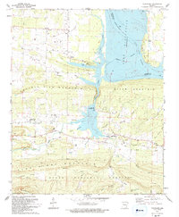
1993 Map of New Blaine
USGS Topo · Published 1993About this map
New Blaine and the surrounding Logan County countryside are defined by the convergence of steep interior ridges and the broad expanse of Lake Dardanelle. This 1993 revision, based on data reaching back to 1958, shows a landscape transitioning from the highlands of the Ozark National Forest and Huckleberry Mountain down to the submerged river valley. The map documents significant local history through its collection of rural cemeteries and religious sites, such as St Scholastica Ch and the Ware Chapel Cem. An Old Railroad Grade traces a path through the northern hills, a reminder of earlier transportation networks that predated the modern recreational development seen at Shoal Bay Recreation Area and Dublin Rec Area. Between the heights of Prairie View Mountain and River Mountain, the terrain is etched by numerous drainages like Big Shoal Creek and Silversmith Branch.
Find a feature on this map
51 named features on this map. Tap any name to fly to it.
Don’t see what you’re looking for? This feature index may not catch every label — zoom into the map to look around manually.
Map Details
Editions of this 1993 New Blaine Map
This is the sole edition of this map. No revisions or reprints were ever made.
Other maps of this area

1879 · Mountain Home
USGS Topo · 1:62,500

1887 · Magazine Mountain #1
USGS Topo · 1:62,500

1887 · Magazine Mountain #4
USGS Topo · 1:62,500

1887 · Magazine Mountain
USGS Topo · 1:62,500

1888 · Dardanelle #2
USGS Topo · 1:62,500

1888 · Dardanelle #3
USGS Topo · 1:62,500

1890 · Magazine Mountain
USGS Topo · 1:125,000

1890 · Dardanelle
USGS Topo · 1:125,000

1956 · Russellville
USGS Topo · 1:250,000
1961 · Hartman
USGS Topo · 1:24,000