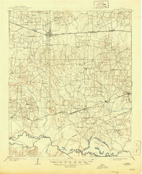
1909 Map of New Boston
USGS Topo · Published 1944About this map
New Boston and the older town of Boston serve as the commercial anchors in this early twentieth-century portrait of Bowie County. The landscape is defined by the east-west corridor of the Texas and Pacific RR (Sherman Line) and the St Louis Southwestern RR, which supported a network of small rail-side communities like Maud, Carbondale, and Whaleys. This survey provides a rare glimpse into the rural social geography of the era, marking numerous community landmarks such as Chalybeate School, Shiloh Church, and Paps School that were vital to the area's residents before modernization.
Find a feature on this map
60 named features on this map. Tap any name to fly to it.
Don’t see what you’re looking for? This feature index may not catch every label — zoom into the map to look around manually.
Map Details
Editions of this 1909 New Boston Map
2 editions found
Other maps of this area

1907 · Atlanta
USGS Topo · 1:62,500

1909 · New Boston
USGS Topo · 1:62,500

1909 · Texarkana
USGS Topo · 1:62,500

1910 · Linden
USGS Topo · 1:62,500

1910 · Atlanta
USGS Topo · 1:62,500

1914 · Daingerfield
USGS Topo · 1:62,500

1930 · Bassett
USGS Topo · 1:62,500

1950 · Redbank
USGS Topo · 1:24,000

1950 · Barkman
USGS Topo · 1:24,000

1950 · De Kalb
USGS Topo · 1:24,000