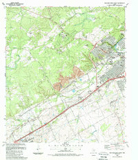
1988 Map of New Braunfels West
USGS Topo · Published 1988About this map
New Braunfels anchors this study of the Comal and Guadalupe county line in the late 1980s. The landscape is defined by the hydrologic complexity of Comal Springs and the sprawling waterways of Dry Comal Creek and Blieders Creek. Industrial and transit corridors dominate the southwestern approach to the city, where the Missouri Pacific railroad runs parallel to established settlements like Solms and Dittlinger.
Find a feature on this map
29 named features on this map. Tap any name to fly to it.
Don’t see what you’re looking for? This feature index may not catch every label — zoom into the map to look around manually.
Map Details
Editions of this 1988 New Braunfels West Map
2 editions found
Other maps of this area

1920 · Smithsons Valley
USGS Topo · 1:62,500

1924 · New Braunfels No 4
USGS Topo · 1:48,000

1925 · New Braunfels No 1
USGS Topo · 1:48,000

1925 · Hunter No 3
USGS Topo · 1:48,000

1927 · New Braunfels
USGS Topo · 1:62,500

1927 · Smithson Valley
USGS Topo · 1:62,500

1929 · Hunter
USGS Topo · 1:62,500

1929 · Smithson Valley
USGS Topo · 1:62,500

1940 · Smithson Valley
USGS Topo · 1:62,500

1953 · Schertz
USGS Topo · 1:24,000
Featured Places
- New Braunfels, TX
- Schertz, TX
- Santa Clara, TX
- Bavarian Village, New Braunfels
- Landa Park Estates, New Braunfels