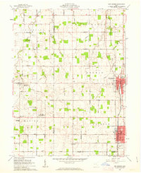
1961 Map of New Bremen
USGS Topo · Published 1963About this map
The town of Minster anchors the southern portion of this West-Central Ohio survey, situated alongside the Miami and Erie Canal. This waterway, marked as abandoned by the early 1960s, follows the eastern corridor past New Bremen, paralleling the New York Central railroad line. The landscape is a testament to the region's strong Catholic heritage, centered on the Maria Stein Shrine and the community of Maria Stein, which shares space with the St Johns post office.
Find a feature on this map
52 named features on this map. Tap any name to fly to it.
Don’t see what you’re looking for? This feature index may not catch every label — zoom into the map to look around manually.
Map Details
Editions of this 1961 New Bremen Map
This is the sole edition of this map. No revisions or reprints were ever made.
Other maps of this area

1908 · St. Henry
USGS Topo · 1:62,500

1909 · Loramie
USGS Topo · 1:62,500

1911 · Loramie
USGS Topo · 1:62,500

1911 · Spencerville
USGS Topo · 1:62,500

1914 · Celina
USGS Topo · 1:62,500

1944 · Loramie
USGS Topo · 1:62,500

1944 · Celina
USGS Topo · 1:62,500

1944 · Spencerville
USGS Topo · 1:62,500

1953 · Muncie
USGS Topo · 1:250,000

1956 · Muncie
USGS Topo · 1:250,000